PLEASE BE AWARE THAT MANY OF THE WALKS AROUND YERRANDERIE ARE OVERGROWN AND POORLY MAINTAINED & SIGNPOSTED. PLEASE DO NOT UNDERTAKE ANY WALKS UNLESS YOU ARE WELL EQUIPPED AND EXPERIENCED TO HANDLE THEM.
If you are looking for information on the Great Burragorang Walk and a possible 3 Day walk to Yerranderie from Bulio, please click HERE to go to there.
Credit: Thanks to Richard and Ruth Thompson for the information on this page.
Yerranderie Peak Day Walk
Yerranderie Peak Walk
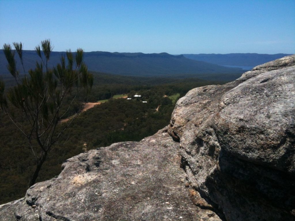
No visit to Yerranderie is complete without a climb of “The Peak” to see the great view from the top. The walk is about 2km return and a climb of around 290m.
From near the Yerranderie airstrip a view of the Peak leaves two impressions. Firstly, that it would be an awesome peak to climb. Secondly, that the band of cliff encircling the massif probably means that a climb is not possible for the ordinary walker.
It is however, possible with care and sufficient experience.
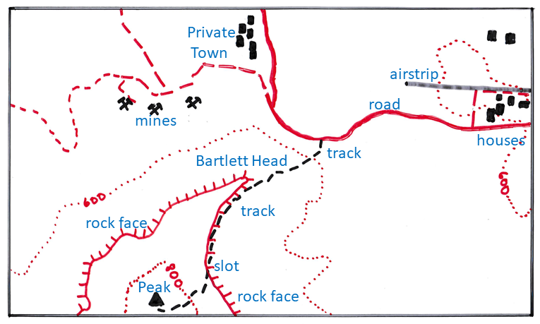
The Peak walk leaves the left of the road between the two sections of Yerranderie about 500m past the houses and the church. The first 250m of track lacks any subtlety heading straight up the hill to a spot under the rock face which is Bartlett Head.
From there the track flattens and travels left along under, or near, the rock face. It becomes steeper as it approaches a slot in the rock face, the secret that makes the climb possible. The climb up the slot is straightforward but take care of falling rocks as there is nowhere else for them to fall! Best for one person at a time and tell those on top not to move around. There are lots of loose rocks and it is easy to lose your footing. Do not attempt this unless you are sure footed and suitably experienced.
From near the top of the slot there is a path back to the right that goes along the top of the rockface to Bartlett Head which is a nice view with less effort than the Peak.
The track up to the Peak can be a bit indistinct at times but basically heads uphill and a little to the left of the peak before turning right and up the final push to the top.
Leave plenty of time for the view which is wonderful in all directions!
Gander Head Day Walk
North of Yerranderie is an extensive area of wild country extending into the distance to the towns of the Blue Mountains such as Katoomba. To the west of this area is the Kowmung River, Kanangra Walls, and Jenolan Caves. To the east is the remote and rarely visited area of the Blue Breaks. The dividing line between these areas is Scotts Main Range Fire Trail which essentially is a continuation of the road through Yerranderie.
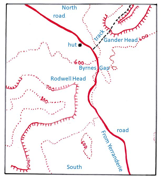
This walk takes you onto the threshold of Scotts Main Range to a nice vantage point to look across this large wilderness. Except for the final ascent of Gander Head it is all on fire trails. The walk starts at the Lodge in Yerranderie Private Town, past Krubi Cottage, and winds down to the Tonalli River. This is a distance of 1.3km and a descent of 80m.
From the crossing of the Tonalli River there is a long uphill section up to Byrnes Gap which is the prominent opening between the upland areas of Gander Head (Axehead Range) and Rodwell Head (Tonalli Range). The distance is 3.6km and the ascent is 130m.
The track to Gander Head is on the right soon after gaining Byrnes Gap and just short of a hut and a cleared area on the left. Follow this at times indistinct track far enough to get the best possible view. The distance is about 400m and the ascent is around 100m so it is quite steep.
The same track continues through the Axehead Mountains, down the Cliffs of Dirt, along the Long Break, and into Green Wattle Creek. All are part of the area known as Blue Breaks. The area is remote being cut off in the east by the Wollondilly arm of the Warragamba catchment and to the north by the Cox’s arm. To the west is the deep valley of the Kowmung River. This is an area of multi-day pack walks almost all off-track and over very rough terrain.