The Yerranderie Airfield has been a vital second access route for our community since the early 1960’s…. until a National Parks’ regional manager decided to refuse us permission to use it.
Why does the Yerranderie Community need this airfield?
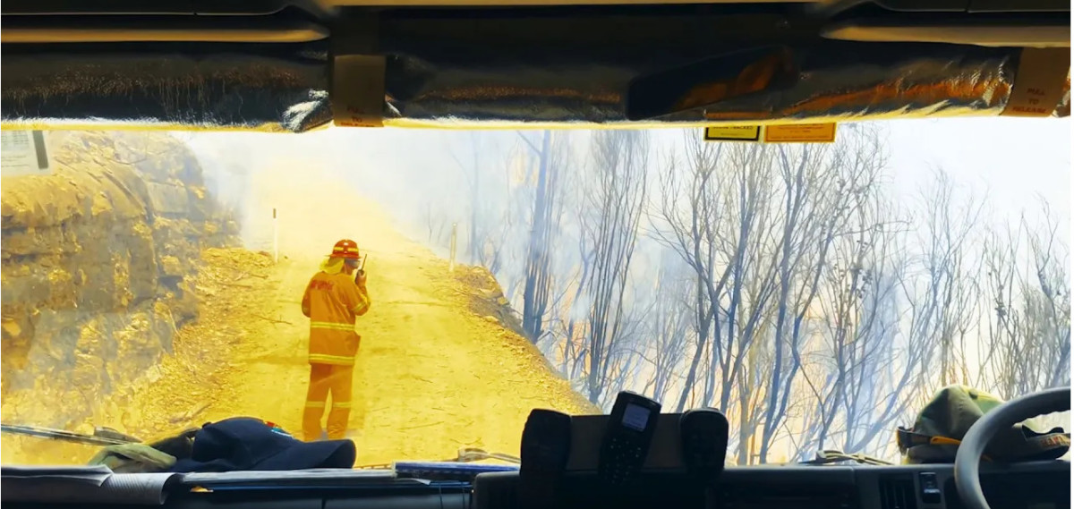
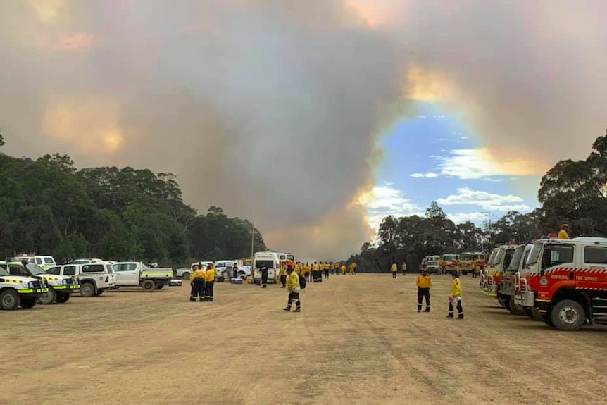
Because we only have one dirt road into and out of town through 64 kilometres of bushland and it looked like this during the 2019 fires…..
….and looked like this after heavy rain last year (2023).
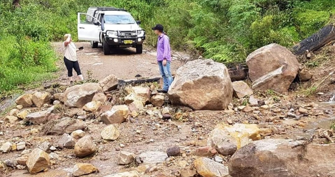
The Yerranderie Airstrip provides vital alternate access when the Oberon Colong Stock Route is closed. In the recent two years of wet weather the Stock Route was washed out and completely impassable for a cumulative total of about 3 months. It was extremely difficult and dangerous to drive for about a further 6 months during the same period. At the time of the 2019 bush fires it was too dangerous to drive on many occasions due to the risk of being trapped by fire fronts.
In early 2024 Val Lhuede wrote to the Environment Minister Penny Sharpe asking that the airstrip be reopened. The Minister handed a review back to the same person who made the original decision to refuse us access. Unsurprisingly he agreed with his original decision and the strip remains closed to the Yerranderie Community.
It is a 15 minute flight in a light aircraft to Camden or The Oaks Airports in South Western Sydney.
Background.
This area in Yerranderie was previously playing fields and grazing land. Pioneer aviation legend Jim Hazelton started using the land as an airstrip in the early 1960’s after the Burragorang Valley was flooded and the road access from the east cut off. During the 1960’s, Valerie Lhuede started a tourist venture on her land at Yerranderie and many visitors and bushwalkers were flown in from Camden and The Oaks airports and given a spectacular scenic joy flight along the way. More information can be found on our Yerranderie Airstrip historical use web page.
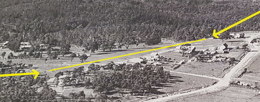
In the 1970’s, Ms Lhuede improved the landing area and the bumps were levelled, smoothed and compacted. The sandy loam is well draining so after heavy rain it only requires a day or two of fine weather before the surface is firm enough again for flying operations.
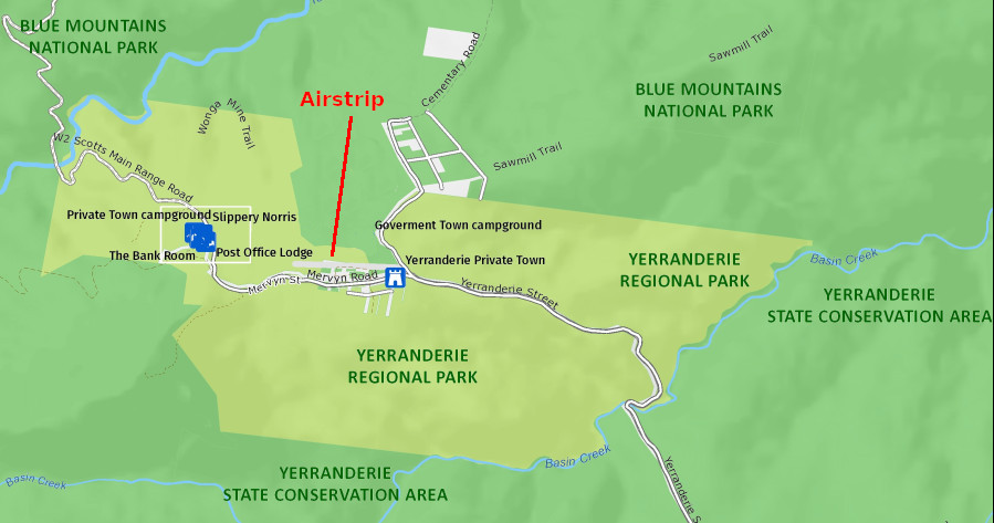
The Cadastre below shows that the south western section of the runway comprises of the easement for Kerry Street which falls under Wollondilly Council and the north western section is Yerranderie Regional Park, previously owned by Valerie Lhuede. The eastern end of the runway is Blue Mountains National Park land. The approaches to the west and east are over Yerranderie Regional Park land.
Yes it is complicated!
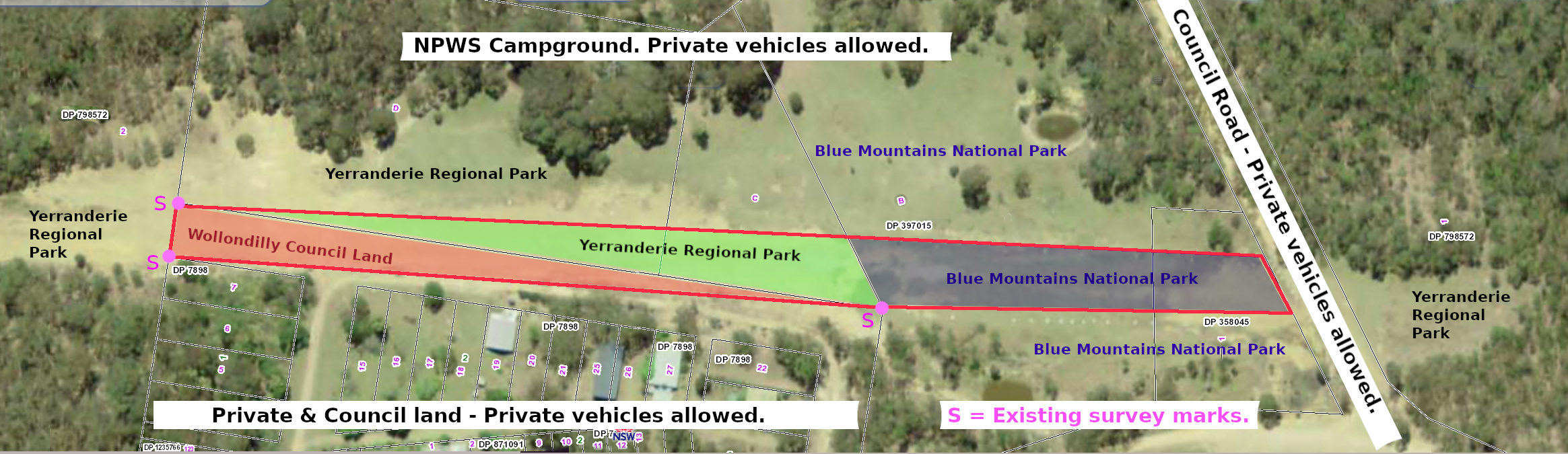
The airstrip is segmented into land controlled by Wollondilly Council and NSW National Parks. In addition, WaterNSW Regulations apply to NPWS land but not to Council or Private land. All these agencies operate under different NSW legislation so there is quite a complex mix of rules and regulations governing this small strip of land.
If you view the above boundaries map in conjunction with the image below, it will help you get a better idea of how this all fits together.
Further geographic analysis can be made by visiting maps.six.nsw.gov.au and zooming to the Yerranderie Township.
There has been much debate about the future of the airstrip but there is almost universal agreement that it it is vital for emergency services use. Small fires in this area can easily escalate and slam into South Western Sydney.
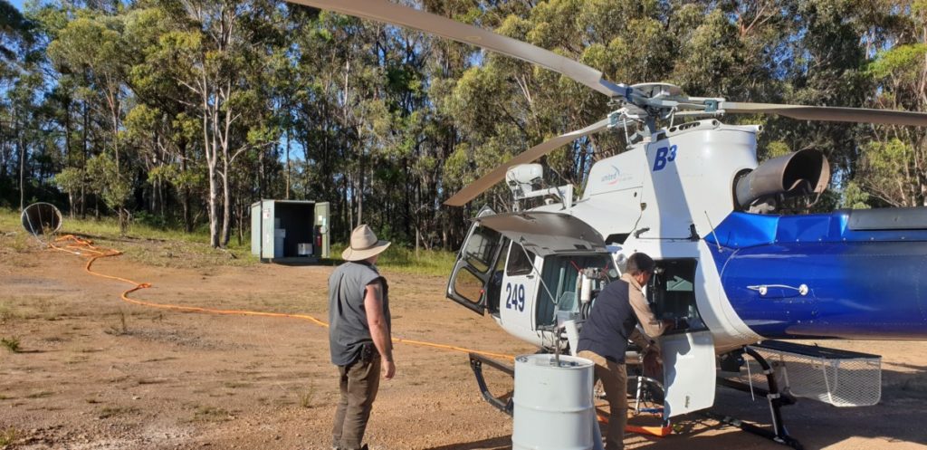
This NPWS contracted firefighting helicopter in the image below extinguished a fire at nearby Burnt Flat last summer. It is an interesting situation that it is parked on Council owned land, it’s water bucket and the refuelling shed are on National Parks land and 200 litre drums of Jet aviation fuel are being rolled across the boundary line. We are advocating for a joint management plan to be developed by Wollondilly Council and National Parks.
The Wollondilly Council Section.
Wollondilly Council is currently considering this situation. Their section is regularly used by NPWS, firefighting and emergency aircraft. It is also used with permission by resident Rob Thompson in his ultralight aircraft which only requires a short runway. This section is not long enough for most commercial charter light aircraft.
As the landing area has been used for around 60 years, the Wollondilly Council land section is likely to have “Existing Use” rights under NSW Legislation which means the use may be able to be continued. We discuss this in a following section on this page.
Wollondilly Council are supportive of collaboration with the NPWS to devise a joint management plan.
The National Parks Section.
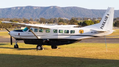
The airstrip is used by National Park helicopters and their Cessna Caravan fixed wing aircraft which is shown in this photo.
The Blue Mountains’ Regional Director David Crust will strictly only allow National Parks and emergency aircraft to use their section of the Yerranderie airstrip. When the Oberon Colong Stock Route road access was cut off for a month he would not allow residents permission to fly to and from Yerranderie or fly in food and supplies in aircraft chartered for the 15 minute flight from Camden.
The two pieces of NSW legislation governing National Parks say very little about aircraft and do not say anything about who can or can’t use an airstrip in a National Park. These are the National Parks and Wildlife Regulation 2019 and the National Parks and Wildlife Act 1974.
Each Park in NSW is required by legislation to have a Plan of Management which would normally contain guidelines for the use of Park assets such an airstrip. NSW Legislation requires a Plan of Management to be drafted “as soon as practicable” after a Park is gazetted and then updated every 10 years.
Yerranderie Regional Park still does does not have a Plan of Management, 13 years after being gazetted!
The NPWS have a Vehicle Access Policy which in Section 58 says “The private landing of an aircraft within a park will generally not be allowed other than in exceptional circumstances”. We sought a legal opinion on this and the response was:
The use of the word “generally” is the salient aspect of Section 58. The Oxford dictionary defines “generally” as “in most cases; usually”. As such, this clearly makes Section 58 to be a guideline, not a hard and fast rule. The Mutawintji National Park Plan of Management (Section 4.2 Items 27 & 28) shows a clear example of a significant deviation from these guidelines in allowing their airstrip to be used for “…commercial tours and a mail run…..special tours or other activities approved by the Board.”
As such, we do not believe that there are any NSW legislation or NPWS policies which absolutely mandate the exclusion of private or commercial light aircraft in a National Park.
Is the airstrip a legally permissible land use?
The airstrip has been used since the early 1960’s when the Burragorang Valley was flooded and public road access from the east was cut. It has been in continuous operation since before the Wollondilly Council zoning was put in place and before Yerranderie Regional Park was Gazetted.
We have prepared a Yerranderie Airstrip historical use web page which we believe shows sufficient evidence that the Yerranderie Airstrip has been continuously used and therefore may be able to continue to do so under the following NSW Legislation….
Under the National Parks and Wildlife Act 1974 Section 39 the use of the National Parks Section airstrip may be defined as an “Existing Interest” which may continue with the approval of the NSW Environment Minister.
The airstrip has been used since before the Wollondilly Council zoning and planning regulations came about so the use may likely continue as an “Existing Use” as defined in Section 4.11 of the Environmental Planning and Assessment Act 1979.
There have been some myths circulating about aviation regulations….
….that Yerranderie Airstrip does not meet the CASA (Civil Aviation Safety Authority) requirements.
Published in November 2021, CASA Advisory Circular 91-02 v1.1 Section 4.1.3 states “There are no standards for aerodromes that are not certified….”
….that the owner of an airstrip has the responsibility to ensure safe aircraft operations.
CASA Advisory Circular 91-02 v1.1 Section 6.2.1 states:
“It is the pilot’s responsibility to be satisfied that the aeroplane is able to safely take off from, or land at, an aerodrome. When operating at an aerodrome, the pilot needs to be aware of any potential hazards.”
Then Section 6.2.2 goes on to describe an exhaustive long list of risk factors which are the responsibility of the pilot to determine. Nearly everything that can possibly go wrong is regarded as the fault of the pilot because he or she shouldn’t take off or land if there are any risks present. It is common for aircraft operators to have $10-20 million public liability insurance and all aircraft landing at Yerranderie should be required to have such a policy.
There has also been misinformation about safety issues….
….that obstacles such as kangaroos and people present an unacceptable danger.
Every light aircraft airstrip in Australia has, at times kangaroos, people and cars encroaching and every pilot is trained how to deal with them.
Yerranderie is a typical “bush strip”. There are many hundreds (maybe thousands) like this across Australia and it is part of a pilot’s training to learn how to deal with these type of strips. Curtis Aviation at Camden previously used our strip to train pilots in the necessary techniques until NPWS withdrew permission.
A typical arrival procedure is to fly along the side of the strip at about 500 feet which gives a clear view of any potential obstacles and people, cars, kangaroos etc can easily be identified. A decision is then made to continue with the circuit and landing or divert to another aerodrome. If there are obstacles such as kangaroos or people it is commonplace to make an approach with a deliberate “go-around”. This involves lining up for a landing but at low level applying power and carrying out another circuit and approach. This alerts people and scares kangaroos away. If the obstructions remain, the pilot must divert to another aerodrome. When taking off, taxiing up and back along the strip serves the same purpose.
….that aviation fuel from light aircraft poses a significant threat.
Many smaller aircraft use plain automotive fuel and some use “Avgas” which is for practical purposes almost identical to 98 premium car fuel. Light aircraft pilots would plan to arrive at a bush strip like Yerranderie with a fairly light fuel load…. about 30 – 50 litres. This is comparable with the motor vehicles arriving in town who often also carry jerry cans with extra fuel. These small aircraft touchdown at much the same speed as most people drive into town.
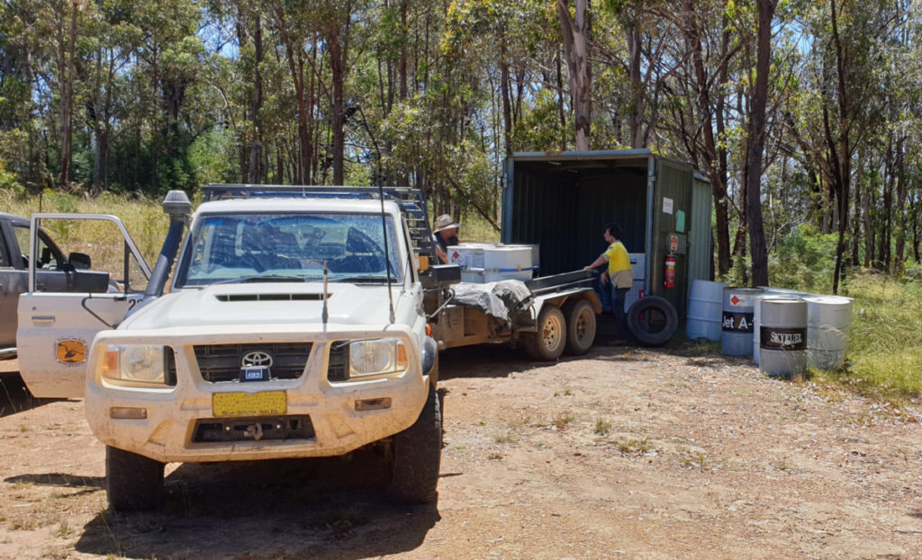
The National Parks’ aircraft using Yerranderie Airfield have fuel tanks with a capacity of up to 400 litres of jet aviation fuel and they regularly store up to 2,000 litres in drums inside the fuel shed on the north western side of airstrip. The 200 litre drums are driven into town on the back of NPWS utes and trailers along 65 kilometres of dirt road via the Oberon Colong Stock Route.
Emergency Services
During the major fires in 2019 – 2020 the airstrip and surrounds became a vital hub for emergency services. Any fires in this area need to be tackled quickly in order to stop them escalating downwind and slamming into the populated areas of the Wollondilly Shire.
Is flying to Yerranderie affordable and viable?
Yerranderie is approximately 10-15 minutes flying time from Camden depending on the type of aircraft. A chartered Cessna 180 from Curtis Aviation at Camden for many years regularly flew in and out of Yerranderie. It takes 3 passengers (with modest baggage) for about $95 per seat each way at current rates. Curtis Aviation also have two Citabria aircraft which have been regular visitors to Yerranderie. They can take 1 passenger each and the cost of the seat is about $85 each way and can also include a flying lesson. The scenery on these flights is spectacular!
Our web page on the historical use of the airstrip will give you an idea on how the airfield was used in the past.
Where to next?
Yerranderie Airstrip is a vital second access route and essential for emergency services. In particular it serves as a base for firefighting aircraft and ground equipment.
The only other access is the Oberon Colong Stock Route which has been closed many times over recent years. It has been twice closed for around month at a time and many shorter closures as a result of the extreme wet weather events. During the 2019-20 bush fires The Stock Route was too dangerous to drive on many occasions.
There are many in our community who support carefully regulated and approved air charter access for residents. There has also been discussions about resuming tourism operations in conjunction with a developed joint tourism plan by Wollondilly Council and National Parks. When Val Lhuede owned Yerranderie she generated significant accommodation and tourist income from “fly-ins”. She used this money for the ongoing and much needed maintenance of the heritage buildings.
It has also been raised by some that the airstrip should be closed and allowed to regenerate to natural bushland. The difficulty with this option would be that after 130 years of human activity, this land is so disturbed and compacted that it would require very considerable money and ongoing effort to regenerate it.
Any future aircraft operations at Yerranderie must be carefully regulated with every pilot or charter operator requiring a valid reason, suitable experience, prior permission and appropriate public liability insurance. A briefing on operating procedures would be required before arrival. It can never be a free for all, drop in airport.